Shabri waterfall google map location
The distance of the Shabri waterfall from Banda is 108 km via Atarra, Chitrakoot, and Pindra(towards Satna)
Manikpur and karwi are the nearest railway station, distance from Manikpur to Shabri Jal prapat is 32 km it takes 45 minutes while traveling by car via markundi village
The distance of shabri jal prapat from Satna is 55 km and it takes around 1 hour 10 min via Kothi and Majhgawa. From karwi, it is 40 km via Pindra
Rishikesh veg Dhaba near Shabri Jal Prapat (Shabri waterfall)
Rishikesh veg Dhaba is the nearest place to shabri waterfall where you can grab a bite, it’s a quiet place in the middle of the highway. it is 3 km from the waterfall
Brahaspati Kund google map location
Banda, Atarra, and Karwi (Chitrakoot) are the nearest railway stations. The distance from Banda to Brahaspati kund is 85 km via Naraini and kalinjar. The travel distance from Atarra is 64 km and karwi (Chitrakoot) is 75 km. Brihaspati kund distance from Khajuraho is 81 km
The distance of Brihaspati kund from Satna is 68km and the distance from Panna is 37 km you can use google map to find the easiest way from your place, I have created a descriptive map for your convenience
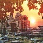
Rahila Sagar Sun Temple Mahoba
The nearest Airports to Rahila Sagar Sun Temple Mahoba are Khajuraho, New Delhi, and Lucknow. The distance of the temple from Lucknow airport is 225 Km, from New Delhi airport is 580 km and Khajuraho airport is 70 km
The nearest Railway station Rahila Sagar Sun Temple is Mahoba and Jhansi and Khajuraho. distance from Mahoba railway station is 3 km, from Khajuraho railway station is 65 km, and from Jhansi is 160 km. From Khajuraho, you can come to Mahoba via train then take an auto for this place. If you are coming from Banda, Chitrakoot, you can take a train/bus to Mahoba.